

CAN you guess where this week’s Mystery Photograph was taken?
Each week, the Journal invites readers to test their local knowledge by identifying a historic location from days gone by.
Last week’s Mystery Photograph was taken at Ston Easton.


.jpeg?width=209&height=140&crop=209:145,smart&quality=75)
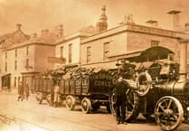

Congratulations to Adam Wyatt who wrote in and said: “Is this week’s mystery photo of the High Street, Ston Easton? This row of five houses is directly opposite the entrance to Ston Easton Park. The grass between Green Street and the main road is now where the postbox and bus stop are situated.”
Ston Easton is a small village and civil parish in Somerset, located near the River Chew. The village has a long history, with its name believed to derive from Old English, meaning a settlement near a stone or rock in the east. Its location along the high ground and proximity to the river made it a favourable site for settlement from early times.
The village is closely associated with Ston Easton Park, an 18th-century country house designed by architect John Wood the Elder, later remodelled by John Wood the Younger. The estate has been central to the village’s development, influencing the layout of roads and housing in the surrounding area. The park and its grounds reflect the wealth and social prominence of the family that owned the estate over the centuries.
Ston Easton historically formed part of the hundred of Chew, an administrative division used in medieval Somerset. Agriculture has long been the backbone of the local economy, with arable farming and pastureland shaping the landscape around the village.
The village retains several historic buildings, including St Mary’s Church, which dates back to the 15th century and features notable architectural details such as a Perpendicular-style tower and intricate interior woodwork. Many of the cottages and houses along the High Street reflect 17th and 18th-century building styles, preserving the character of the village.
Comments
This article has no comments yet. Be the first to leave a comment.